We drove there along the Calder Freeway (it's all Freeway now) as far as Elphinstone where we turned "inland" towards Sutton Grange, Mandurang and Strathfieldsaye. Along the way we stopped to do a Geocache by a creek near Sutton Grange, and then went on all the way to Strathfieldsaye just outside of Bendigo.
The next stop was Kennington Reservoir, where I found a second Geocache.
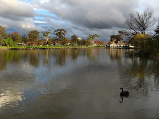
Next was lunch, had in the car by Lake Weeroona. Sandwhiches from home along with hot jam doughnuts bought from one of two caravans beside the lake.
One of the main reasons for the trip was for mum to visit Bendigo pottery to top up the dinner set. After getting some plates and bowls it was back on the road and into the back blocks of White Hills to look for a house where a relative used to live. Successfully found, we continued on and made our way to Eaglehawk before heading back to Bendigo proper via a round about sort of route.
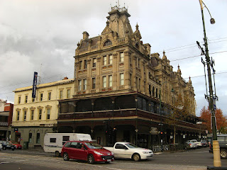
 Old Buiding, now a museum and tourist
information centre.
I should know what it was originally, but can't remember.
I suspect it was whwere the kept the gold Does anyone know?
I had two more Geocaches on my list for the day, so we went back to lake Weeroona to look for the first. It was really busy on this side of the lake and had to wait ages to get a car park. Then I had to be extra sneaky to retrieve the cache without being seen. While I was waiting for my chance I made friends with a swan.
The final Geocache I found before heading home was near the Bendigo station.
We stuck to the Calder Highway all the way back to Melbourne.


2 comments:
Considerably more water in the creek/drain than when we were there. Great lake photo. It was so grey when I snapped away.
It might not look it, but it was freezing cold that day. I'm pretty sure it was snowing on Mount Macedon under all that cloud. It was also pretty wet, so that would explain all the water in the creek.
Post a Comment